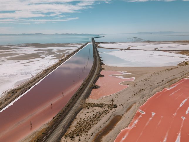
Scientists are warning Utah officials that the Great Salt Lake is shrinking far faster than experts previously believed, and calling for a major reduction in water consumption across the American West in order to prevent the lake from disappearing in the next five years.
Researchers at Brigham Young University (BYU) led more than 30 scientists from 11 universities and advocacy groups in a report released this week showing that the lake is currently at 37% of its former volume, with its rapid retreat driven by the historic drought that’s continuing across the West.
Amid the climate crisis-fueled megadrought, the continued normal consumption of water in Utah and its neighboring states has led the Great Salt Lake to lose 40 billion gallons of water per year since 2020, reducing its surface level to 10 feet below what is considered the minimum safe level.
“Goodbye, Great Salt Lake,” tweeted the Environmental Defense Fund on Friday.
Goodbye, Great Salt Lake👋 Megadrought and mismanagement have cost the lake 73% of its water. Now experts are warning it could dry up in the next 5 years. And “Its disappearance could cause immense damage to Utah’s public health, environment, and economy”https://t.co/oecZ0qQ8C0
Scientists previously have warned that increased average temperatures in Utah—where it is now about 4°F warmer than it was in the early 1900s—are to blame for a 9% reduction in the amount of water flowing into the lake from streams.
The authors of the BYU study are calling on Utah officials to authorize water releases from the state’s reservoirs and cut water consumption by at least a third and as much as half to allow 2.5 million acre feet of water to reach the lake and prevent the collapse of its ecosystem as well as human exposure to dangerous sediments.
“This is a crisis,” BYU ecologist Ben Abbott, a lead author of the report, told The Washington Post. “The ecosystem is on life support, [and] we need to have this emergency intervention to make sure it doesn’t disappear.”
The shrinking of the Great Salt Lake has already begun creating a new ecosystem that is toxic for the shrimp and flies that make it their habitat, due to the lack of freshwater flowing in. That has endangered millions of birds that stop at the lake as they migrate each year.
The loss of the lake may also already be exposing about 2.5 million people to sediments containing mercury, arsenic, and other toxins.
“Nanoparticles of dust have potential to cause just as much harm if they come from dry lake bed as from a tailpipe or a smokestack,” Brian Moench, president of Utah Physicians for a Healthy Environment, told the Post. Last month, Moench’s group applauded as Republican Gov. Spencer Cox’s administration, under pressure from residents, walked back its position supporting a plan to allow a magnesium company to pump water from the Great Salt Lake.
Abbott called the rapid shrinking of the lake “honestly jaw-dropping.”
“The lake’s ecosystem is not only on the edge of collapse. It is collapsing,” Abbott told CNN. “The lake is mostly lakebed right now.”
Deep in the San Francisco Bay, two rivers splinter into a vague triangle, creating one of the richest watersheds in California. This estuary – the Sacramento-San Joaquin River Delta – is an important source of freshwater for the 4 million folks who live in the region. Local agricultural, fishing, and recreation industries bring in billions of dollars a year, and the area also provides a rich habitat for local wildlife.
Over the past few decades, this watershed has seen a dramatic change in its climate. Years-long droughts and record-high temperatures have transformed the region – a shift that’s told no better, perhaps, than through the story of the Delta smelt.
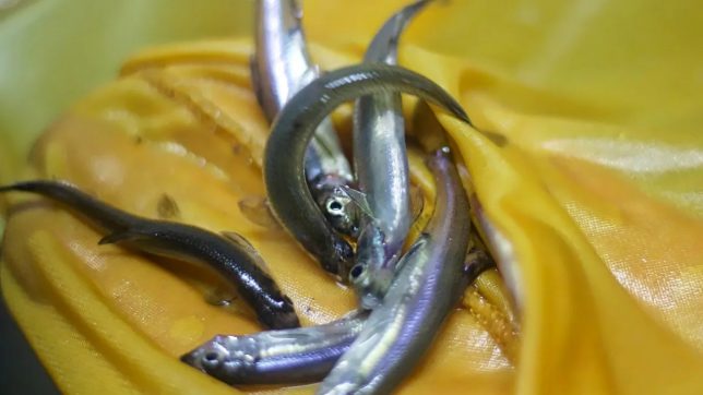
The Delta smelt is an iridescent fish about the size of a finger. The fish is a bioindicator, often noted for its distinct smell of fresh cucumbers. Though small in size, it has an impact reaching beyond the Delta, all the way to Capitol Hill. The smelt’s role in Northern California’s decades-long “water wars” have made it a key player in shaping the region’s water policy.
A harbinger of threats to other species
As a bioindicator, its presence in the Delta signifies a healthy ecosystem – one that can support a diverse range of life. However, not since the 1980s have the fish been abundant in the wild.
To Tien-Chieh Hung, PhD, director of the Fish Conservation and Culture Laboratory (FCCL) at UC Davis, it’s simple: “If these fish are going extinct, then there are other species that are going to be listed as threatened or endangered, too.”
There was a time when these fish swam through the Delta in the thousands. Trawling surveys would pull up nets full of their thin, shimmering bodies. It’s now rare for these surveys to catch even one.
In fact, the largest known population of Delta smelt doesn’t live in the Delta at all. They live, instead, just south of the watershed, in large white circular lab tanks Hung oversees at the FCCL, now rearing a captive population in the tens of thousands.
This decades-long effort has been meticulous. The smelt was listed as threatened in 1993 but the project to culture the fish was established only a decade later, in 2004. Since then, FCCL scientists each year scour the estuary in search of wild smelt. Each such specimen found is then transported into the lab to be tagged and genetically cataloged.
The careful genetic classification of each wild Delta smelt has been key to preserving the genetic diversity of the captive population to keep it as similar to the wild stock as possible. For years, when breeding season comes along, this genetic catalog is carefully consulted to pair-up smelt for mating new generations in the lab. But keeping this cultured population diverse has become harder over the past decade as finding wild smelt has become rarer in the estuary.
The hard reality: In 2021, California’s Department of Fish and Wildlife’s Fall Midwater Trawl Survey found none at all, prompting scientists to do something they have been putting off for years – begin preparing for the first release of cultivated smelt into the wild.
A long troubling history, and now comes climate change
The Delta smelt raised in captivity do not smell much like cucumbers. Hung mentions that this trait seems to be connected to stress. The smelt at the FCCL have no predators, perfectly saline water, and plenty of food piped into their tanks. Their lives in the Delta are much less comfy.
Importantly, the Delta smelt evolved specifically in, and is named after, the ecosystem of the San Francisco Bay Delta, for thousands of years having an estuary with cool, freshwater running through its many channels. The watershed in modern times feels very different: According to scientist Peter Moyle, associate director of the Center for Watershed Sciences at UC Davis, “that [original] habitat just isn’t there.”
Irrevocable changes in the smelt’s ecosystem began in the 1800s. Non-native species – like the bluegill and largemouth bass – were introduced to the watershed for sportfishing. Fish very similar to the Delta smelt, like the silverside and wakasagi, were introduced soon after as supplemental food for these new game fish. The former meant more predation for the Delta smelt, the latter meant more competition.
In addition to these new fish in the Delta, regional water programs like the Central Valley Project and the State Water Project began operating in the 1960s. These projects diverted water flows in the estuary to serve communities in Northern California and, consequently, turned the watershed more saline than brackish.
All of this, coupled with rising temperatures and consistently historic droughts in the region, have created a deadly Delta for the smelt; though this is also a realityformanyestuaries,worldwide. “Climate change,” said Moyle, “has just accelerated things.”
The Delta smelt has a lifespan of only one year, and its population was initially devastated by a prolonged drought in the 80s. This time, however, recovery proved particularly difficult because conditions continued to worsen and some non-native species adapted to these changes better than the smelt. In past droughts, smelt populations have diminished even as populations of introduced silversides increased.
“We use the term regime shift,” said Brian Schreier, a scientist with the Department of Water Resources (DWR) in West Sacramento, about the smelt’s decline. And this regime shift was not so easy to reverse. Even as the conditions in the estuary worsened, millions of people still relied on these water projects to survive.
Steps leading to boosting number of smelt in the wild
In 2008, the US Fish & Wildlife Service (USFWS) issued a Biological Opinion (BiOp) that expanding the export of water from the Delta would severely impact the smelt population. That action mandated that measures, like reduced pumping, be taken to prevent such a future for the fish. That 2008 BiOp was reversed in 2019, however, when the Trump administration issued a new statement claiming that the smelt population would be fine given that the FCCL has spent decades rearing a robust captive population to supplement the wild fish.
Even though the FCCL’s plan has always been to eventually release these fish into the wild, scientists have resisted doing so for nearly 20 years. They expressed concerns that the captive population might not be fit for conditions in the wild, or that they would adversely impact the wild smelt population that is surviving.
Water and Power Law Group’s Natural Resource Counsel, Paul Kibel, recalls the way hatcheries failed at replacing salmon populations in a 2020 article “Salmon Lessons for the Delta Smelt.” “The replacement assumption has proven faulty,” Kibel wrote, “as the total abundance of salmon declined at the same time the propagation and release of hatchery salmon has expanded.” In the case of the salmon, the replacement population not only increased competition for their wild counterparts, but they had also been domesticated in the hatchery and were unfit to survive in the wild.
These were real concerns also for scientists working with the smelt. And though the 2019 BiOp placed excessive and perhaps unreasonable emphasis on the hatchery fish solution, it may have also – temporarily, at least – saved the Delta smelt.
“That was the first regulatory document that actually had legal backing,” said Schreier, “and effectively mandated that supplementation would occur.” And, late last year, for the first time ever, supplementation finally did.
‘A roller coaster’ as 12,000 hatchery smelts were reintroduced
December 15, 2021, marked the first release of hatchery Delta smelt into the wild. More than 12,000 of these fish were transported from their cool, roomy tanks in the FCCL and placed into several barrels in the back of a pick-up truck. They were then driven to Rio Vista where the barrels were transported to a boat and sailed into the channels of the Delta, where the fish were finally released together.
The road to this release was “a roller coaster,” according to Schreier: It involved many months of experimental trial releases where select populations of hatchery fish were exposed to conditions of the Delta in aluminum cages specially designed to prevent their escaping even as food and fresh water flowed through.
“We started under what we thought would be the best conditions,” said Melinda Baerwald, an ecologist at the DWR, about the caged trials. “To be perfectly honest, we didn’t have high hopes.” But she says she was pleasantly surprised when this first trial had a nearly 100% survival rate of the captive smelt.
The research team then tried exposing the hatchery population to progressively worsening conditions to see how they would fare, another step that proved reassuring. Baerwald recalls one of the last caged trials they did last summer. “It was fairly shocking,” she said.
The team took the smelt out to the Yolo Bypass in the middle of a heat wave. They weren’t expecting the smelt to stay alive for about a week. “But the fish kept surviving,” she said.
74 wild smelt is more than zero … but ‘a desperation measure’?
Since the first release in December, four more releases have occurred in two additional locations. And, since these releases have taken place, local trawling surveys have picked up 74 smelt, compared to the previous number of consistently zero.
Baerwald and Schreier wanted these releases to take place in the wintertime to ensure the best chances of survival in the increasingly warming Delta. They also mentioned that doing the releases during cooler months allows the captive Delta smelt to spawn the next generation directly in the rivers so they can begin their lives in the watershed.
The scientists are hopeful, but Moyle says it’s also “a desperation measure.” The factors that caused the wild smelt’s original decline have still not been properly addressed and the smelt are facing increasingly dire conditions. California and much of the U.S. West, has also been in a drought since February 2020 and the beginning of 2022 continues to be historically dry.
One may wonder what hope there is, really, for such a little fish as the Delta smelt. Human combustion and emissions of fossil fuels continue to cause unprecedented warming around the world. And these hotter temperatures have also been noted to increase drought severity. So long as temperatures continue to rise as predicted, the Delta of today – plagued with unrelenting droughts and contested water projects and chemical runoff – will never be the Delta of the smelt’s past.
And eventually, without a proper habitat to enter into, those hatchery fish will have nowhere to go to.
Hanisha Harjani is a reporter, artist, and student, currently attending UC Berkeley Graduate School of Journalism.
Water authorities in the Western U.S. don’t know what the future will bring, but they are working collaboratively and with scientific rigor to make sure they’re prepared for anything.
Editor’s note: This story is part of a four-part series — “Hotter, Drier, Smarter: Managing Western Water in a Changing Climate” — about innovative approaches to water management in the U.S. West and Western tribal nations. The series is supported by The Water Desk , an independent journalism initiative based at the University of Colorado Boulder’s Center for Environmental Journalism. You can read the other stories in the series, along with more drinking water reporting, here.
In a thirsty Western United States that has become increasingly vulnerable to extreme weather events, rampant wildfires and years of unprecedented drought, those at the helm of the region’s water agencies are accelerating their plans to grapple with climate change.
“The Western United States — especially the 40 million people who use the Colorado River — we’re in the bullseye of climate change,” says Cynthia Campbell, water resource management advisor for the City of Phoenix. “This is not a conceptual conversation anymore. We’re in full-on adaptation.”
With that reality comes the need to plan around the future of water for the people and wildlife who call the Colorado River Basin home.
“You can’t just plan for one future.”
–Carly Jerla
But, says Carly Jerla, an operations research analyst for the United States Bureau of Reclamation’s Lower Colorado Region, “you can’t just plan for one future.”
As climate change casts its shadow over water resources in the Western U.S., water authorities must navigate uncertainty in the form of the many possible futures in front of them. Those futures almost certainly hold more of what climate change has already brought — rising temperatures, changes in precipitation, shifts in snowpack, longer and more severe droughts, more frequent flooding — plus people’s responses to those changes. Taken together, these fateful forecasts go into climate projections: models that explore an array of possible future climate conditions or scenarios.
Today, planning agencies are working together to diversify the technology they’re using and integrate scientific research into local and regional adaptation strategies in an effort to be rigorous in their analysis of the uncertainty.
Adapting to climate change “shouldn’t be scatter-shot,” Campbell says. “It can actually be more scientific.”
Mix of Solutions
Although local regulations vary among Western water agencies, the inclusion of climate projections into authorities’ planning processes has become all but universal. Grappling with uncertainty requires water managers to account for supply and demand challenges that are (and will be) driven by climate change, says Jerla, who is currently stationed at the University of Colorado Boulder. On the supply side, she explains, are factors such as higher temperatures, precipitation and snowpack changes, and droughts and flooding. Shifts in demand, meanwhile, are from things like rising evapotranspiration rates in agriculture and impacts to residential irrigation.
A longtime expert on modeling applications and planning operations for the Lower Colorado Region, Jerla was the study manager for the Bureau of Reclamation’s Colorado River Basin Water Supply and Demand Study. The assessment was completed in 2012, and its technical foundations helped guide climate adaptation policies. The research, which occurred under the umbrella of the agency’s larger Basin Study Program, quantified water imbalances through 2060 and suggested potential strategies for mitigation and adaptation.
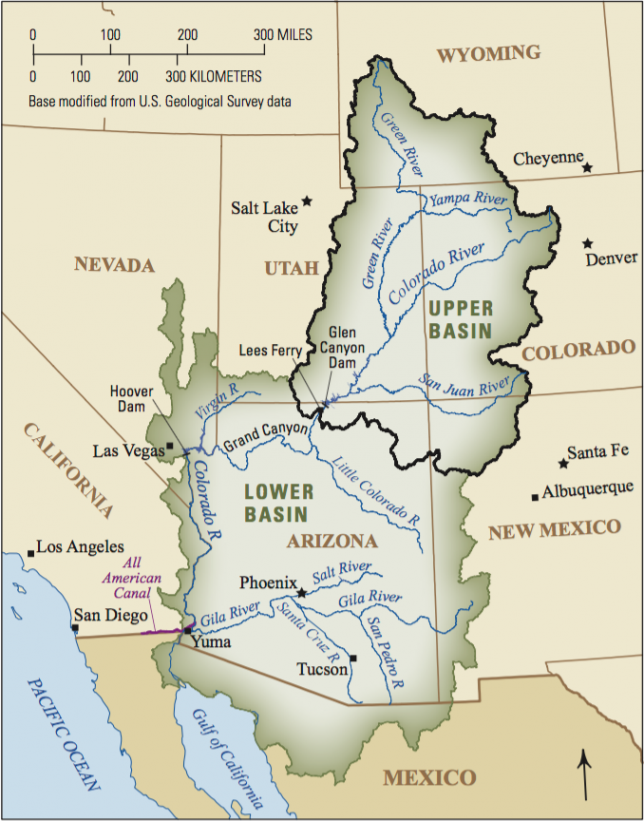
For water authorities in the Colorado River Basin states, climate change means uncertainty in the form of the many possible futures in front of them. Photo courtesy of the U.S. Geological Survey (public domain).
The study identified shortfalls between projected supplies and projected demand in the Colorado River Basin by looking at a range of possible future climatic scenarios and analyzing many possible outcomes, according to Jerla. One particular scenario, called a downscaled general circulation model (GCM), forecasted that as the climate continues to warm, the mean natural flow of the Colorado River at Lees Ferry, Arizona — significant because it’s the point that separates the river’s Upper and Lower Basin, and from which water allocations for the Basin states are determined depending on river measurements — would decrease by about 9% over the next 50 years, alongside longer, more frequent droughts.
“One of the things that this opened our eyes to is the importance of communicating the uncertainty with respect to future outcomes, especially when you’re looking 50 years in the future,” Jerla says.
In addition to examining these scenarios, she and her colleagues evaluated adaptation and mitigation strategies that might reduce supply and demand imbalance. One important conclusion, according to Jerla, was the notion that water agencies would need to diversify their portfolios to include a variety of mechanisms like water reuse, desalination and increased water transfers to urban areas.
“There was no one solution that was going to be a fix-it,” Jerla says. “It has to be a mix of stakeholders involved.”
A Critical Period
The next few years will be a critical policy planning period for Western water agencies, culminating in the particularly pivotal year of 2026. The drought contingency plans for the Upper and Lower Basins of the Colorado River, which have helped further the understanding that the status quo is no longer sustainable, will expire that year and likely undergo significant changes. In the plans, first approved by Congress in 2019, the seven Colorado River Basin states committed to protect the water levels of Lake Powell and Lake Mead — the human-made reservoirs that store Colorado River water and serve the basin states — through various conservation mechanisms.
Not only will the Colorado River Drought Contingency Plan expire in 2026, so too will the 2007 Colorado River Interim Guidelines for Lower Basin Shortages and Coordinated Operations for Lake Powell and Lake Mead, as well as the terms of the International Boundary and Water Commission’s Minute 323 — an updated “implementing agreement” of the Mexican Water Treaty of 1944 that established U.S.-Mexico protocols for collaborative management of the Colorado River. Experts agree that new negotiations on the interim guidelines, as well as between the U.S. and Mexico on a new Minute, will be instrumental in shaping collaborative water management for the future, which will no doubt involve serious consideration of climate change projections.
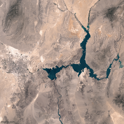
Persistent drought has contributed to the ongoing drawdown of Lake Mead—a large reservoir straddling the Nevada and Arizona border. The decline is visible in these images, acquired 15 years apart with instruments on Landsat satellites.
The initial image was acquired July 24, 2015 with the Operational Land Imager (OLI) on the Landsat 8 satellite. The second image was acquired July 6, 2000, with the Enhanced Thematic Mapper Plus on Landsat 7. During this period, the lake’s elevation (measured near the Hoover Dam), dropped by about 37 meters (120 feet). Turn on the image comparison tool to see how the drop in water level has changed the lake’s perimeter. NASA Earth Observatory images by Joshua Stevens (public domain).
“In the Colorado River Basin, we’ve been at work really since the Interim Guidelines for Powell and Mead Operations, since 2007, slowly building and adding to our operational decisions, planning efforts, policies — all with a mind toward more flexibility, enhanced resiliency, preparing for the challenges ahead, building science into the activities,” Jerla says.
For the Colorado River, Jerla and her colleagues have been making projections about relevant reservoir elevations through 2025, as they know what the operational guidelines will be until 2026. Generating such projections and sharing them with their local and regional partners remains crucial in order to help stakeholders understand what water reductions they might need to make.
Jerla says she is confident in the “robust set of policies” in place through 2026, which specify the water reductions that both U.S. states and Mexico will need to implement when the basins reach specified levels. Although she acknowledges the “dismal hydrology” that the region will likely encounter for the next five years, Jerla expresses hope that through “the spirit of cooperation the basin will come together.”
A Collaborative Approach
Beyond 2026, once new guidelines are in place, Jerla says she envisions more collaborative decision-making, more incorporation of science and more involvement from area tribes and Mexico as the region embraces new action plans for coping with a drier future.
While the Bureau of Reclamation has taken responsibility for many of the climate modeling efforts and continues to work collaboratively with local programs, it is the states that “have the most primary responsibility for allocating and receiving the water in their own state,” with their own sets of water laws and systems, Jerla explains. Down another level, she adds, local government authorities, urban municipalities, water councils and water associations employ the state regulations to manage water supplies on a local level. As a federal body, the Bureau’s role is to facilitate agreements across state boundaries — a process that has largely gone smoothly through mutual consensus.
“All the states have interests and priorities. The Colorado River ties us together.”
–Amy Ostdiek
“All the states have interests and priorities,” says Amy Ostdiek, deputy section chief at the Colorado Water Conservation Board, a cohort appointed by the governor to represent each major Colorado basin and relevant state agencies. “The Colorado River ties us together.”
As demands have continued to shift, the Colorado River Basin states have been “negotiating and renegotiating,” with a keen interest in furthering collaborative solutions, Ostdiek says. The Bureau of Reclamation, she explains, has always played a key role in this process, but planning occurs at the state level.
Individual states are now implementing the commitments made in the 2019 Drought Contingency Plan. Upper Basin states, which sit upriver from the Lower Basin states and are therefore responsible for not depleting the flow of the Colorado River, are focused on planning for a future with less water. Colorado itself sits at the headwaters of the river and is exploring options such as temporary compensated reduction of use, in which water users could get paid for using less water, Ostdiek explains.
Internally, state water agencies also have individual programs that focus on a sustainable future, such as the 2015 Colorado Water Plan. The Water Plan was Colorado’s first such program and in its first five years funded more than 241 water projects, such as infrastructure improvements, irrigation efficiency measures and engagement projects like taking science teachers on a five-day trip of the Rio Grande to show them various water issues facing Colorado. Set to be updated in 2022, the Water Plan builds upon previous supply planning and projects how much water the state will need in the future, according to Megan Holcomb, climate change risk management specialist at the Colorado Water Conservation Board.
A recent pilot initiative of the Water Conservation Board, the Future Avoided Cost Explorer (FACE:Hazards), aims to anticipate Colorado’s economic impacts from flood, drought and wildfires in 2050. The study, funded predominantly by the Federal Emergency Management Agency, according to Holcomb, paired four population scenarios (ranging from current population to high growth) with three climate scenarios (current, moderate and more severe change). The authors then discussed actions that Coloradans could take to reduce economic impacts from these hazards, as well as the relative cost associated with each action.
“If we can quantify what impacts from climate change will be without any action, then we have a baseline to say why resilience investments are worthwhile now,” Holcomb says.
Another internal Coloradan water program that takes climate change into account is the Drought Task Force, which is able to recommend mitigation measures as necessary statewide. While the governor makes the ultimate decision regarding these measures, the Task Force involves representatives from departments of natural resources, public safety and agriculture, among others.
Moving forward, both Ostdiek and Holcomb say that operational flexibility and a willingness to adopt creative solutions will be key to coping with climate change in water planning. Due to Colorado’s unique headwater position — which already limits how much Colorado River water the state is entitled to each year — Holcomb argues that Colorado needs to be particularly creative about water rights by furthering innovative tools like water leasing, which allows water rights holders to lease their water to other users.
“We can all acknowledge that we need to be able to share within the state as well,” she says.
At the other end of the Colorado River Basin, water officials in Phoenix, Arizona, are recognizing that some 40% of the city’s water supply may be in jeopardy due to climate change, according to Campbell from Phoenix Water.
That’s one reason, Campbell explains, planners in Arizona are observing shifts in the flow pattern of the Colorado River that are the direct result of climate change. She and her colleagues are strategizing how they might replace the supplies that are in jeopardy — looking at exact times and places where reductions can be made through “targeted demand management.”
For example, Campbell suggests, a project could work to reduce the amount of water used by cooling towers at a power plant by studying the precise impact of changing the water used by certain towers. Such adaptation tactics, according to Campbell, would have a much more significant impact than, for example, shutting off the water while brushing teeth — a practice that, while good for conservation, is “not going to yield the type of water we’re talking about.”
And because the amounts of water experts are talking about are not set in stone, dealing with that uncertainty will continue to be a critical responsibility of water agencies going forward. Collaboration and scientific rigor are key, all these experts agree, to making sure the region is as prepared as possible for any future that may present itself.