BLM California manages nearly 600 producing oil and gas leases covering more than 200,000 acres and 7,900 usable wells. More: Between 80% and 90% of all surface-disturbing activities related to oil and gas activities occur in the San Joaquin Valley on public lands administered by Central California District, Bakersfield Field Office. More than 95% of all Federal drilling occurs in established fields within the Kern County area of the San Joaquin Valley.
The oil and gas program in California is one of the more active in all of the western states, with 2013 onshore oil production figures ranking the State as the 3rd most productive state in the United States. In 2012, California was ranked as the 13th most productive natural gas-producing state. BLM California is responsible for managing one of the most productive individual onshore leases in the lower 48 states, and four of the nation’s top seven producing oil fields are located in Kern County. As a general rule, California’s Federal production totals average approximately 8%-10% of California’s total oil and natural gas production. Original public domain image from Flickr
On October 7, California took a bold step in combatting climate change. Governor Gavin Newsom signed two pioneering bills, SB-253 and SB-261, that not only bolster greenhouse gas (GHG) emissions reporting but also mandate prominent companies to unveil their climate-related financial risks. What makes this move especially notable is its scope; even exceeding the requirements set by the U.S. Securities and Exchange Commission in 2022.
What Does SB-253 Entail?
Companies with annual revenues surpassing $1 billion in California will now be obligated to disclose their GHG emissions each year. By 2026, both direct and indirect emissions fall under this mandate. And come 2027, the requirements will be even more stringent. However, there’s a bit of leniency; companies that report scope 3 emissions, which are notoriously challenging to quantify, will face milder penalties provided they report in a genuine effort. The stakes are high; failure to comply can result in fines of up to $500,000 per year. However, to keep things in perspective, $500,000 is a mere 0.0083% of Chevron’s net income of $6.01B.
The Significance of SB-261
Marking a debut at the state level, SB-261 makes it compulsory for businesses with yearly earnings exceeding $500 million to publicly disclose their climate-related financial threats and preventive measures. This requirement kicks off on January 1, 2026, with non-compliance potentially costing companies up to $50,000 annually.
Who’s in Charge?
The responsibility of implementing these groundbreaking laws rests with the California Air Resources Board (CARB). They’re set to engage in rule-making processes in 2024 and will actively seek input from concerned stakeholders. Yet, the path might not be smooth; legal challenges are anticipated, suggesting that the future of these laws may be determined in court.
The Implications for Big Players
Corporate giants in California, such as Chevron and Apple, now find themselves under the spotlight. They need to account for broader emission sources, which include aspects like supply chains and product usage. And with these rigorous Californian regulations, the state is setting a precedent, outpacing both federal and state norms. Furthermore, global powerhouses like Apple and Microsoft are gearing up for these disclosures. While California stands strong with its firm economic position, its guidelines prove more demanding than those at the U.S. federal level.
The Bigger Picture
While reporting scope 3 emissions might be complex, it underscores vital areas of transformation. When companies consistently and transparently disclose their emissions, it can catalyze real climate action. As a testament to this, the U.K.’s emission disclosure rule led to a noteworthy 8% reduction in corporate emissions.
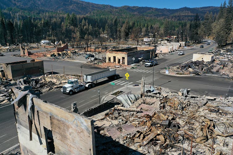
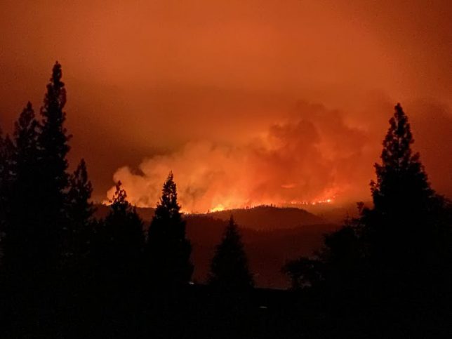
Californians have been concerned about wildfires for a long time, but the past two years have left many of them fearful and questioning whether any solutions to the fire crisis truly exist.
The Dixie Fire in the Sierra Nevada burned nearly 1 million acres in 2021, including almost the entire community of Greenville. Then strong winds near Lake Tahoe sent the Caldor Fire racing through the community of Grizzly Flats and to the edges of urban neighborhoods, forcing the evacuation of tens of thousands of people – including one of us. Those were only the biggest of the 2021 fires, and the risk isn’t over. A wind-blown fire that started Oct. 11 was spreading quickly near Santa Barbara on the Southern California coast.
As foresters who have been working on wildfire and forest restoration issues in the Sierra Nevada for over a quarter of a century, we have found it painful to watch communities destroyed and forests continuing to burn to a crisp.
The main lesson we gather from how these fires have burned is that forest fuels reduction projects are our best tools for mitigating wildfire impacts under a changing climate, and not nearly enough of them are being done.
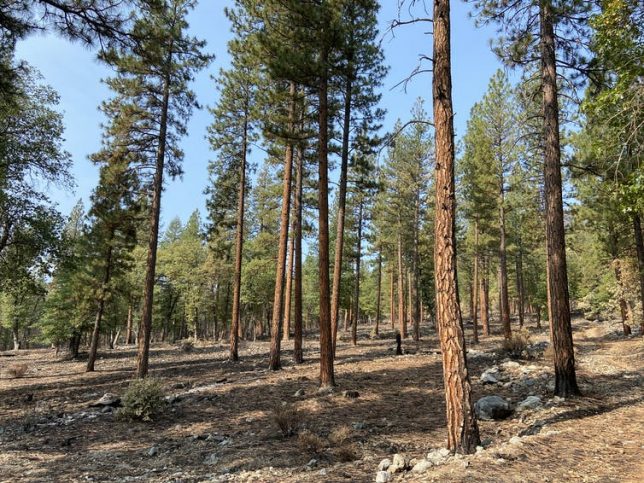
Thinned areas like this one in California’s Genessee Valley were more resistant to 2021’s Dixie Fire. Ryan Tompkins, CC BY-ND
Two historic policies, in our view, led the western U.S. to the point where its forests have become so overgrown they’re fueling megafires that burn down whole communities.
Fire suppression
The first policy problem is fire suppression and exclusion.
Fire is an essential ecological process, and many of the ecosystems in the West are adapted to frequent fire, meaning plant and wildlife species have evolved to survive or even thrive after wildfires. But most people arriving in California during colonization, both before and after the Gold Rush of 1849, fundamentally misunderstood the nature of frequent fire forests.
As state and federal agencies evolved policies on forest management, they considered all fire to be an existential problem and declared war. The U.S. Forest Service kicked off a century of fire suppression in the West after the devastating fires of 1910, known as the “Big Blowup” or “Big Burn,” by implementing the 10 a.m. policy. It aimed for full suppression of all fires by 10 a.m. the day after they broke out.
The second policy issue is the regulatory approach that grew out of past logging practices.
Foresters and early California communities were interested in forests for lumber and fuel wood. They sent the largest – and most fire-tolerant – trees to mills to be turned into lumber, which was used to build California’s cities and towns.
Poorly executed logging in some areas led to concerns from residents that forest cover and habitat was shrinking. As a result, state and federal regulations were developed in the 1970s that require managers proposing forest projects to consider a “no action alternative.” In other words, maintaining dense forest habitat in the long term was considered a viable management choice.
On private land, few owners today thin the forest to levels that would mimic the more fire-resilient forests found in the Sierra at colonization. The California Forest Practices Act until recently required replanting after timber harvest to levels much more dense than were found at colonization. In other words, our current regulatory framework promotes maintaining high levels of forest density, when much more drastic removal of vegetation is needed.
Taken together, these policies have promoted 21st-century forests that are younger, denser and more homogenous – making them vulnerable to increasingly severe disturbances such as drought, insect outbreaks and fire. This new reality is exacerbated by a changing climate, which turns the regulatory assumption that active and widespread forest management is riskier than no management on its head.
Agency priorities change as the crisis grows
Just as forests have changed, so too have the agencies that manage and regulate them. The U.S. Forest Service has seen its budgets for fighting fires balloon while its capacity to proactively manage forests has been shrinking. The California Department of Forestry and Fire Protection, known as CAL FIRE, has also seen large increases in firefighting budgets, though the state legislature has recently moved to increase fire prevention funds, too.
Living in communities threatened by wildfires this summer, we are very grateful to firefighters who have saved our homes. Yet we also are concerned that more large, high-severity wildfires burning across the landscape mean less funding and staff will be available for proactive fuels reduction projects like forest thinning and prescribed fires.
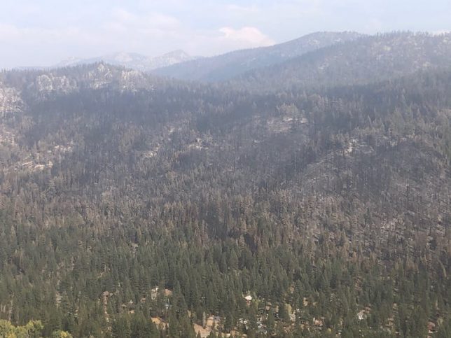
The Caldor Fire burned on both sides of Christmas Valley, but was stopped from burning into the community by firefighters using areas where fuels were reduced before the blaze. Susie Kocher, CC BY-ND
How do we get out of this mess?
The Dixie and Caldor fires that destroyed Greenville and Grizzly Flats provided evidence that forest fuels reduction projects can work.
Both fires burned less severely in areas with proactive forest restoration and fuels management projects, including near South Lake Tahoe and near Quincy.
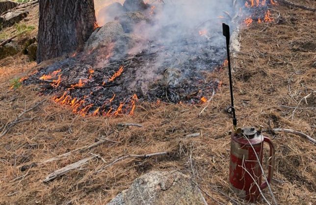
Fuels reduction projects include thinning out trees, burning off woody debris and reducing “ladder fuels” like small trees and brush that can allow fire to reach the tree canopy. They create more open forests that are less likely to fuel severe megafires. They also create strategic areas where firefighters can more easily fight future blazes. And, because fires burn less intensely in thinned forests, they leave more intact forest after a fire for regenerating new trees and sequestering carbon. Prescribed fires and managed ignitions paid huge dividends for containing the Dixie and Caldor fires.
During the Dixie Fire, firefighters used an area that had been strategically thinned in the past to set backfires to prevent the wildfire from spreading into the community of Quincy. Ryan Tompkins, CC BY-ND
To manage fires in an era of climate change, where drier, hotter weather creates ideal conditions for burning, experts estimate that the area treated for fuels reduction needs to increase by at least an order of magnitude. We believe government needs to accomplish these four things to succeed:
Drastically increase funding and staff for agencies’ fuels reduction projects, as well as outreach, cost-sharing and technical assistance for private forestland owners. Although the Biden administration’s proposal for a Civilian Climate Corps proposes funding to bring in more young and unskilled workers, funding more federal and state agency positions would recruit more natural resource professionals, provide career-track opportunities and better add forest restoration capacity for the long term.
Reduce regulations on forest and fuels management efforts for both public and private land. While California and the federal government have made recent strides to streamline regulations, land management agencies need to acknowledge the biggest risk in frequent fire forests is doing nothing, and time is running out. Agencies need to drastically cut the time needed to plan and implement fuels reduction projects.
Invest in communities’ capacity to carry out local forest restoration work by providing long-term support to local organizations that provide outreach, technical assistance and project coordination services. Funding restoration through competitive grants makes development of long-term community capacity challenging at best.
Provide funds and financial incentives for at risk communities to retrofit homes to withstand wildfires and reduce fuels around homes, communities and infrastructure.
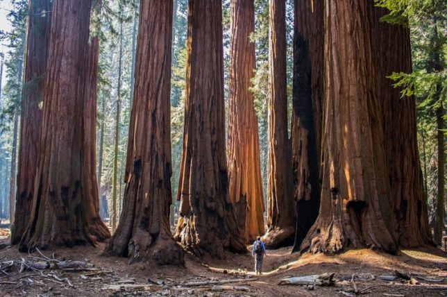
The sequoias that live on the western slopes of the Sierra Nevada in California are the largest trees in the world by volume. Erin Donalson/EyeEm via Getty Images
Editor’s note: As wildfires came dangerously close to Sequoia and Kings Canyon National Parks in September 2020, the curator of the archives there worked with Emily Lin, librarian and head of digital curation at the University of California Merced, to evacuate the archives to keep them safe. In this interview, Lin explains how they evacuated the records, what’s in them and why they’re worth preserving.
Listen to Emily Lin of UC Merced talk about the archives and see the contents of the park archives and photos from the evacuation.
Why were the archives of Sequoia and King’s Canyon National Parks evacuated?
Ward Eldredge, the curator of the archives of the Sequoia and Kings Canyon National Parks, and I had been talking about the potential partnership around digitization of collections that had been housed there for a couple of years now. There’s been a concern about the safety of these records because wildfires in the past few years have been an annual threat. So the long-term safekeeping of the records was very much on Eldredge’s mind. And he pointed out that the UC Merced campus is located in one of the few areas in California that are outside of a high-risk fire zone and also outside of the risk of earthquakes. There was just no question that we would do whatever we could to bring them here for safekeeping.
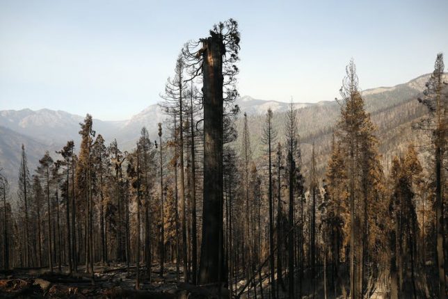
The Castle Fire in October 2020 burned hundreds of Sequoias in the privately owned Alder Creek grove that NGO Save the Redwoods League purchased less than a year ago. Al Seib/LA Times via Getty Images
In September, when the fires got really close to the park, Eldredge was trying really hard to find a way to move the materials. He just couldn’t find a van or a truck because the residents in the area were also being called to evacuate, and there was a shortage. So in the course of a day, we managed to make arrangements to take our moving truck from campus, and he was able to secure a U-Haul truck. We were able to pack everything and move it out of the mountains to the UC Merced campus, which is two and a half hours away.
What’s in these archives?
There were hundreds of boxes of collections, about 600 linear feet, and also cabinets of plant specimens and artifacts.
It’s a complete record of the administrative history of the park. Sequoia was the second-oldest national park in the U.S., established in 1890. So there are records related to its founding and through to the 20th century. In letters written by the park directors to the U.S. president and the secretaries of the Department of the Interior, one can see how the thinking around managing public lands, conservation, fire and forest management changed over the last century.
Before the park was established, people would cut the sequoias down for timber. The city of Los Angeles wanted to build a dam in Kings Canyon up until 1965. So you can see how the thinking changed and how we got from that way of thinking to really establishing the National Park Service and protecting these unique environments.
There’s an incredible photographic record – tens of thousands of photographs that cover pretty much every place within the park. There are maps of the sequoia groves, maps related to how trails and roads and other buildings were constructed. We take these trails for granted, but they were huge undertakings involving hundreds of workers breaking rocks, cutting trees and excavating for years. They worked through the winter sometimes to do it within schedule. These projects also provided jobs during the Great Depression.
Who will find them useful?
Anyone, from those within the parks who want to better understand the history of the park, to the rangers and the interpreters who want to provide and present that history to the general public. Ken Burns, the acclaimed documentary filmmaker, accessed these records while he was making his television series about the national parks.
They’ll also be more widely available for students to use. There’s plenty of material in there for lots of Ph.D. students working on dissertations and for those who want to really investigate how best to manage public lands and determine what’s effective. That knowledge is going to benefit the broader public and help conserve these national parks for all of us. There’s a rich record that can help us understand what is unique about the environment that allows these trees to survive.
What are the plans for keeping the archives at UC Merced?
When the records were kept in the park, it was just one person, Ward Eldredge, maintaining the records. That’s a lot of work. You could make an appointment and he could provide access if you wanted to come to the park, but it’s in a very small space within the park headquarters, so the accessibility was definitely limited. Now that these collections are at the library at UC Merced, it will be easier for people to be able to access them.
Our vision is to be able to digitize much of this material. Once it’s online, it will be a lot easier for people to at least see and maybe answer some of their immediate questions. And if there’s a need for them to see the physical material, they can still make arrangements to do that.
There’s still a long way to go, because normally, we would have to make a plan with the National Park Service, raise funds, build the facilities to store them safely and so on. Because we had to evacuate them, we still have to work on formalizing an agreement, but our goal is eventually to make sure that these records will be safe.